 By admin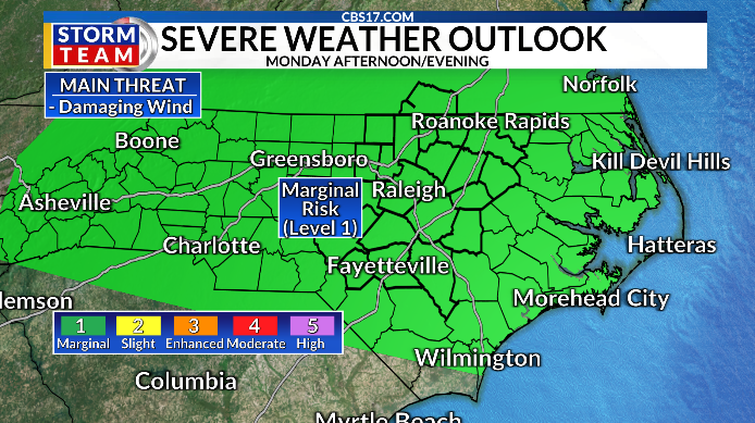
After a severe thunderstorm watch for central North Carolina until 8 p.m. Sunday, the new week will bring with it new chances for severe weather.
Read more Scottie Scheffler gets bad bounces and a big break. It adds to a close call at British Open
The Storm Prediction Center has a risk of severe storms on Monday, Tuesday and Wednesday. Damaging winds will be the primary concern, with localized flooding in areas that see the heaviest cells.
Monday won’t be as hot as recent days, only topping out around 90 degrees under partly cloudy skies. But the afternoon and evening carry a low-end severe weather risk with scattered showers and storms around.

Tuesday will be a similar day, with a similar severe weather threat and highs in the lower 90s as a cold front approaches from the north.
That cold front will spark a good chance for more widespread showers and storms on Wednesday, and an increased risk of severe weather. As the front passes by, we could see damaging wind gusts again. But fantastic changes arrive once the front passes.

Thursday and Friday will feature dry conditions, with lots of sunshine. More importantly, it’ll be less humid with highs only in the middle 80s. Unfortunately, it doesn’t last long.
By next weekend, highs will be back in the upper 80s with lower 90s the following week.

Only a pop-up shower or storm is expected, though, as the overall pattern turns drier.
Read more 5 family members found dead after flash flood in a scenic Utah canyon, authorities say
We’re still watching the Gulf for a system moving northwest in the coming days.
Although it won’t head towards North Carolina, tropical moisture will be funneled our way, leading to the hefty rainfall totals expected.
As much as 1-2 inches or more could fall over the next 7 days combined.

FORECAST
OVERNIGHT will be mostly cloudy with lingering showers and storms. The low will be 72. Winds will be calm.
MONDAY will be partly cloudy with showers and storms, some strong. The high will be 90. Winds will be light and variable.
TUESDAY will be partly cloudy with another round of gusty showers and storms. The high will be 92. Winds will be out of the southwest at 5 to 10 miles per hour.

Follow the CBS 17 Storm Team on socials for the latest weather updates:
Chief Meteorologist Wes Hohenstein: Facebook | X | Instagram
Morning Meteorologist Rachel Duensing: Facebook | X | Instagram
Meteorologist Ross Whitley: Facebook | X | Instagram
Meteorologist Matthew Huddleston: Facebook | X | Instagram
This forecast was prepared by the CBS 17 Storm Team and is based on the latest information available and years of weather forecasting experience in North Carolina. It was not produced by a computer like many forecasts you find on the web, social media and smart phone apps.
Read more Conor McGregor suffered torn ACL in shortened return fight against Max Holloway