 By admin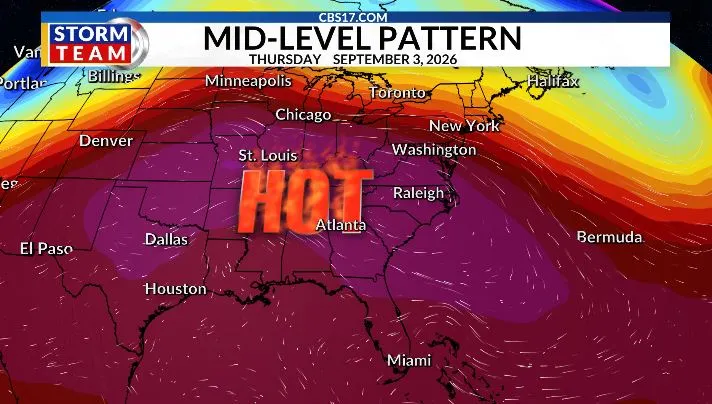
September is set to begin with a return to intense and potentially dangerous heat. Highs will climb into the middle and upper 90s on multiple afternoons next week, with humidity pushing heat index values as high as 105 degrees. This will be a prolonged stretch of heat, with limited relief expected once the pattern becomes established.
Read more Dream’s Reese has 8th technical of the season rescinded by WNBA, avoiding 1-game suspension

The culprit is a large ridge of high pressure building across the Southeast. Sinking air beneath the ridge will suppress cloud development and rain chances while allowing temperatures to soar. With plenty of sunshine and increasing heat, record temperatures will be possible on several afternoons, especially during the middle of the week. We’ve already set more record highs in 2026 than any other year on record, and this upcoming heat could add to that impressive total.

Before the heat really ramps up, Sunday will be noticeably cooler, with highs in the upper 80s and a stray shower or thunderstorm possible. After that, temperatures will quickly climb, setting the stage for the hottest weather of the new month.
In the tropics, Tropical Storm Dolly was short-lived, with increasing wind shear and dry air disrupting the system before it could become better organized. Dolly has since weakened into a tropical wave, and while some thunderstorms have redeveloped, the environment remains unfavorable for significant strengthening. The National Hurricane Center is monitoring the remnants for possible redevelopment as they move west, but even if a new circulation does not form, the system will continue to push a surge of tropical moisture into the Caribbean and nearby islands, bringing periods of heavy rain and gusty winds.
For now, dry air and wind shear are limiting development, but conditions can change quickly as these waves move westward into the warmer western Atlantic. We’ll continue watching the next waves coming off Africa closely as the Atlantic Hurricane Season hits its peak in September.

FORECAST
SUNDAY will be partly cloudy with a stray shower or storm. The high will be 89. Winds will be out of the northeast at 5 miles per hour.
Read more Tarik Skubal greeted mostly with cheers and smattering of boos in Detroit return with Dodgers
OVERNIGHT will be partly to mostly cloudy. The low will be 72. Winds will be light out of the south.
MONDAY will be sunny and hot. The high will be 95. Winds will be light out of the south.

Follow the CBS 17 Storm Team on socials for the latest weather updates:
Chief Meteorologist Wes Hohenstein: Facebook | X | Instagram
Morning Meteorologist Rachel Duensing: Facebook | X | Instagram
Meteorologist Ross Whitley: Facebook | X | Instagram
Meteorologist Matthew Huddleston: Facebook | X | Instagram
This forecast was prepared by the CBS 17 Storm Team and is based on the latest information available and years of weather forecasting experience in North Carolina. It was not produced by a computer like many forecasts you find on the web, social media and smart phone apps.
Read more Tampa Bay Rays set for new $2.3B stadium project after county and city approve financing plan