 By admin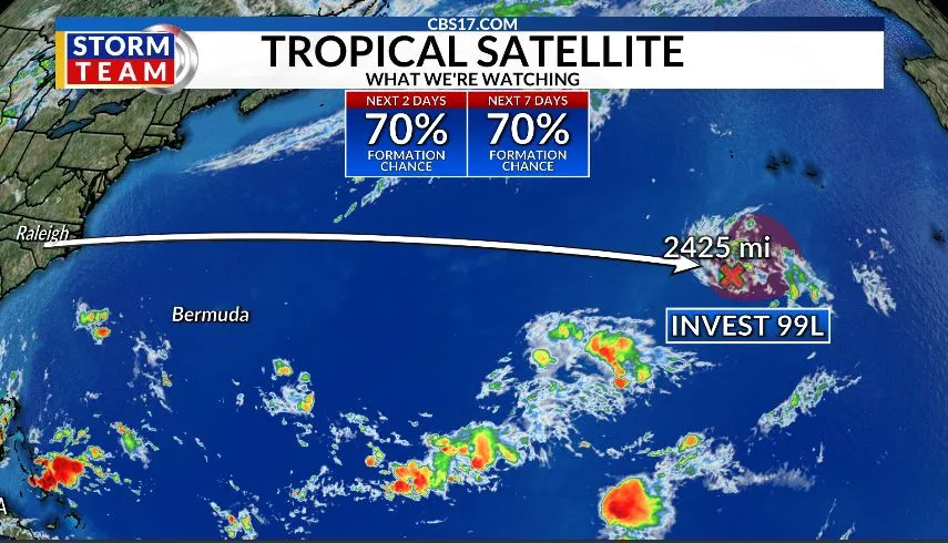
RALEIGH, N.C. (WNCN) — The Atlantic finally has another tropical system worth watching, but Invest 99L is not a threat to North Carolina at this time.
Read more Part of central NC under severe thunderstorm warning as cold front brings unsettled weather Friday
The bigger concern over the next one to two weeks is the evolving pattern across the Caribbean, Gulf of Mexico, and western Atlantic.
Invest 99L is located several hundred miles southwest of the Azores in the eastern Atlantic. Thunderstorms have become better organized around the area of low pressure, and a more defined circulation is beginning to develop.
The National Hurricane Center says the system could become a tropical depression, with a 70% chance of development over the next 48 hours and seven days. For Raleigh and the rest of North Carolina, the track is the most important part of the forecast.

99L is expected to move slowly and remain well out over the Atlantic. Current forecast guidance does not indicate a turn toward the Carolinas or a direct threat to the U.S. East Coast.
Why we’re watching 99L
The system is notable because the Atlantic has been exceptionally quiet this hurricane season.
As of September 18, the Atlantic has produced just five named storms, zero hurricanes, and zero major hurricanes. Accumulated Cyclone Energy, or ACE, is only 4.4, roughly 94% below the 1991–2020 average. One of the biggest factors behind the lack of activity has been the developing strong El Niño. El Niño has contributed to stronger upper-level winds and increased vertical wind shear across much of the Atlantic.


That shear can disrupt thunderstorms and prevent tropical disturbances from becoming organized, particularly across the Main Development Region between Africa and the Caribbean. 99L will have to overcome some of those same environmental challenges as it moves across the Atlantic.
No current threat to Raleigh
For central North Carolina, there is no reason to be concerned about 99L right now.
Read more Cooper Rush to make 2nd straight start at quarterback for Falcons in home opener against Panthers
The system is far too distant to have any immediate impact on Raleigh, and the current forecast pattern keeps it over the open Atlantic. There is no indication at this time that 99L will turn west toward the Carolinas.
That doesn’t mean the system should be ignored. September remains the peak of Atlantic hurricane season, and tropical systems can change quickly when environmental conditions become more favorable.
However, there is an important difference between monitoring a tropical disturbance and having a storm that poses a threat to North Carolina. 99L currently falls firmly into the first category.
What CBS 17 is watching in next 2 weeks
The bigger concern over the next one to two weeks is not 99L, but the evolving pattern across the Caribbean, Gulf of Mexico, and western Atlantic.

Long-range forecast guidance has been hinting at the potential development of a Central American Gyre, or CAG, as several large-scale weather features begin interacting across the region. A CAG is a broad area of low pressure that can develop over Central America and nearby portions of the Caribbean.
These setups can produce significant rainfall and, under the right conditions, allow energy and moisture to transfer between the eastern Pacific and Atlantic basins. Some long-range models have been repeatedly showing tropical development in the Gulf or northern Caribbean. That is a signal worth watching, but it is not a forecast for a specific storm.
The pattern is still several days to more than a week away, and small changes in the position and strength of the large-scale features could completely change the outcome. For now, the Atlantic remains heavily influenced by El Niño and strong wind shear. 99L is worth monitoring, but there is no current threat to North Carolina. The next couple of weeks will be more about watching whether the larger-scale pattern becomes favorable for development across the Caribbean and Gulf of Mexico.
Read more A new stage for ‘¡GOOOOL!’: Andrés Cantor’s next move is to Netflix for Women’s World Cup