 By admin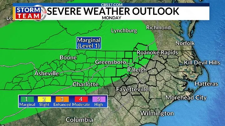
Another warm day is on tap Monday ahead of a frontal boundary moving through central North Carolina.
Read more 1 dead, 1 hurt in Person County double shooting on Helena Moriah Road: Sheriff
The warmth and instability ahead of the front will provide fuel for thunderstorms and a few storms could become strong to severe. The Storm Prediction Center has placed central North Carolina under a Marginal Risk for severe weather, meaning there is a 5% chance of severe storms within 25 miles of a given location.
Coverage will remain limited, with only about a 30% chance of rain across the Raleigh area. The main threats from any stronger storms will be gusty winds, frequent lightning, and locally heavy rain. The front will be slow to clear the region, setting the stage for a much cooler and wetter pattern beginning Tuesday.
A strong area of low pressure will develop along the East Coast Tuesday and strengthen into a powerful coastal storm. Its circulation will turn winds across central North Carolina to the northeast, keeping cooler air and moisture in place through much of the week.
Showers will become more widespread Tuesday and Wednesday, with periods of rain potentially continuing into Thursday. The developing upper-level low and persistent northeast flow could keep clouds and showers around even as the main coastal storm pulls farther north.
Temperatures will be a major change from the summer-like warmth we’ve experienced recently. Highs will generally remain in the lower to mid-70s for much of the week, with persistent clouds and rain making it feel even cooler at times.
Rain totals could exceed an inch in some locations by the end of the week, with at least some measurable rainfall expected across much of central North Carolina. The wettest period currently looks to be Tuesday and Wednesday.
The timing is fitting: astronomical fall officially arrives Tuesday afternoon. The developing coastal storm and the accompanying northerly and northeasterly winds will help deliver a distinctly cooler feel just as the new season begins.
Read more Pakistan says airstrikes target militant hideouts in Afghanistan, killing 28. Kabul says 3 killed
In the tropics, Tropical Storm Fay is far from the Carolinas and poses no threat to North Carolina. The system is located roughly 2,500 miles from the Carolina coast. The quiet Atlantic remains unusual for this point in the season, but the tropical basin will continue to be monitored as we move through the final weeks of September.
FORECAST
MONDAY will be partly cloudy with isolated storms in the afternoon. The high will be 92. Winds will be out of the southwest, changing to north at 5 to 10 miles per hour.
OVERNIGHT will be partly cloudy with isolated showers; a storm is possible. The low will be 69. Winds will be out of the northeast at 5 to 15 miles per hour.
TUESDAY will be mostly cloudy with showers and a storm possible. The high will be 72. The wind will be out of the northeast at 10 miles per hour

Follow the CBS 17 Storm Team on socials for the latest weather updates:
Chief Meteorologist Wes Hohenstein: Facebook | X | Instagram
Morning Meteorologist Rachel Duensing: Facebook | X | Instagram
Meteorologist Ross Whitley: Facebook | X | Instagram
Meteorologist Matthew Huddleston: Facebook | X | Instagram
This forecast was prepared by the CBS 17 Storm Team and is based on the latest information available and years of weather forecasting experience in North Carolina. It was not produced by a computer like many forecasts you find on the web, social media and smart phone apps.
Read more Germany’s Merz struggles to stay on track after humiliating regional election defeat