 By admin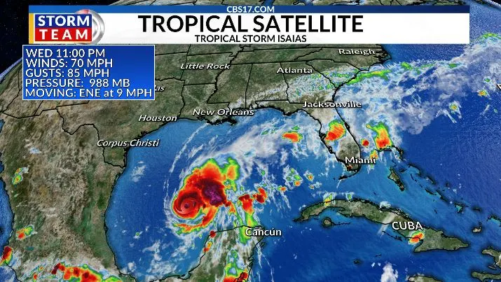
The Atlantic hurricane season has finally produced its first hurricane, and it is happening unusually late.
Read more Rain chances increase by weekend in central NC, as strengthening Isaias looms in the Gulf
Hurricane Isaias became the first hurricane of the 2026 Atlantic season late Wednesday night, potentially tying the record for the latest first hurricane ever recorded in the Atlantic. The current record was set on October 8, 1905.
Isaias reached hurricane strength over the extremely warm waters of the Gulf of Mexico and is expected to reach the northern Gulf Coast Friday. The National Hurricane Center is forecasting Isaias to become a strong hurricane, reaching Category 2 strength, before weakening somewhat as it encounters stronger wind shear near the coast.
The unusually quiet hurricane season has been strongly influenced by the powerful El Niño pattern. El Niño typically increases wind shear over the Atlantic, making it much harder for tropical systems to organize and strengthen. That pattern has helped keep the Atlantic remarkably quiet through the peak of hurricane season, with Isaias becoming the ninth named storm but the first hurricane of 2026.
Major impacts expected along the Gulf Coast
The most significant impacts from Isaias will occur along the northern Gulf Coast. The current forecast calls for the storm to approach the coast late Friday or early Saturday, with the greatest threats coming from storm surge, hurricane-force winds, and flooding rainfall. A Storm Surge Watch is in effect from the mouth of the Mississippi River eastward to Yankeetown, Florida.
The current forecast calls for 5 to 7 feet of storm surge in portions of the Mississippi, Alabama, and western Florida Panhandle coastline, with significant flooding also possible around Mobile Bay. Hurricane conditions are possible along portions of the Florida Panhandle, Alabama and Mississippi coast.
Read more Fall foliage increasing in NC mountains, with local peak expected next month
Heavy rain will also spread inland, with the potential for several inches of rain and locally much higher totals near and east of the storm’s track. Tornadoes will become another concern as rainbands move inland Friday night and Saturday.


What to expect in Central North Carolina
For Central North Carolina, Isaias is not expected to bring a direct hurricane impact at this time. The storm should be weakening substantially as it moves northward through the Southeast, but its moisture will still be capable of producing a period of unsettled weather across the region.


The biggest concern for Raleigh, the Triangle and surrounding areas will be rainfall and gusty winds, particularly Saturday into Sunday. The exact timing and rainfall totals will depend on how quickly Isaias moves north and how much interaction occurs with the upper-level trough over the eastern United States.
Some locations could pick up 1 to 3 inches of rain, with locally higher amounts possible. A few stronger thunderstorms cannot be ruled out, especially if enough instability develops along and ahead of the storm’s remnants. Gusty winds are also possible, particularly across eastern North Carolina.
The good news is that the storm should be considerably weaker by the time it reaches Central North Carolina. The current NHC forecast has Isaias becoming post-tropical as it moves into the Ohio Valley, with the strongest winds and most significant flooding threat remaining closer to the Gulf Coast and farther south.
Read more Yankees make 4 errors in sloppy playoff loss to Rays that leaves them on brink of elimination