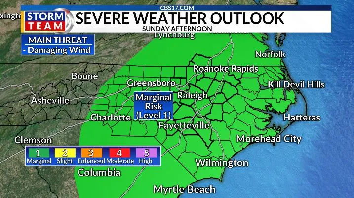
Central North Carolina will have one more round of storm chances Sunday before the focus shifts to what could be the most intense stretch of heat so far this year. A marginal risk (Level 1 of 5) for severe weather is in place on Sunday, with the main concern being damaging wind gusts.
Read more Serena Williams gets Centre Court for Wimbledon return in 1st round match vs Maya Joint
Scattered storms will develop along and ahead of a cold front during the afternoon and evening. While not everyone will see rain, any storm that becomes stronger could bring gusty winds, frequent lightning, and heavy downpours.

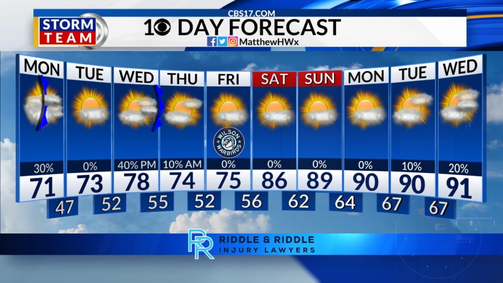
Once that front fades, the pattern flips quickly. July begins on Wednesday with temperatures surging toward 100 degrees as a strong upper-level ridge builds over the Southeast. That ridge will strengthen through the holiday week, likely producing four consecutive days of 100-degree heat or higher from Thursday through Sunday.

If the forecast holds, several daily records could fall, making this one of the most significant heat waves central North Carolina has seen so far this year. Combined with rising humidity, heat index values may climb even higher, creating dangerous conditions for anyone spending extended time outdoors.

Rain chances will be limited under the strong high-pressure dome, but not completely absent. Isolated to scattered pop-up storms remain possible each afternoon, including on the Fourth of July, when highs could reach 102 to 104 degrees. Any storm that forms could briefly knock temperatures down, but many areas will stay dry.
The pattern begins to relax early next week, with highs easing back into the mid-90s. While that will offer some relief, temperatures will still remain above average, and the summer heat looks far from finished.
Read more Ukrainian strike sets fire to an oil refinery in southern Russia

FORECAST
SUNDAY will be partly cloudy with a few stronger storms later in the day and evening. The high will be 92. Winds will be west at 5 miles per hour.
OVERNIGHT will be partly cloudy. The low will be 72. Winds will become calm.
MONDAY will be mostly clear with isolated storms. The high will be 91. Winds will be northeast at 5 to 10 miles per hour.
Follow the CBS 17 Storm Team on socials for the latest weather updates:
Chief Meteorologist Wes Hohenstein: Facebook | X | Instagram
Morning Meteorologist Rachel Duensing: Facebook | X | Instagram
Meteorologist Ross Whitley: Facebook | X | Instagram
Meteorologist Matthew Huddleston: Facebook | X | Instagram
This forecast was prepared by the CBS 17 Storm Team and is based on the latest information available and years of weather forecasting experience in North Carolina. It was not produced by a computer like many forecasts you find on the web, social media and smart phone apps.
Read more 911 center consolidation gets green light from Cumberland County commissioners