 By admin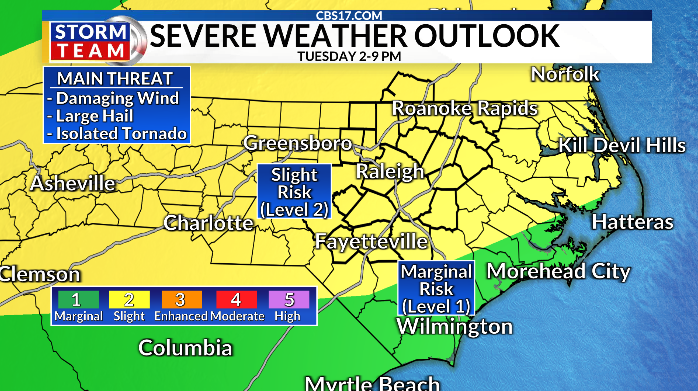
RALEIGH, N.C. (WNCN) — A weather Alert Day has been issued by the CBS 17 Storm Team for Tuesday.
Read more VIDEO: Two parrots reunited with NC owners after escaping this weekend
The entire area is under a slight risk (level 2) from the Storm Prediction Center for severe weather.
What to expect on the Alert Day
The primary threat is a squall line of damaging winds between 2 p.m. and 9 p.m. Tuesday afternoon and night.
But the threat also exists for large hail and an isolated tornado or two, especially across the northeast portion of the area.
A cold front moving south will approach the region by the early afternoon hours. Ahead of the front, a solid line of showers and storms will form and pack a punch as it pushes through. Models are suggesting the squall could begin to bow out as it moves by, leading to a widespread damaging wind threat into the evening.
Any discrete cells would pose the greatest hail and tornado threat. There will be plenty of instability for the storms to work with, as temperatures climb back into the lower 90s with very high humidity values.
Once the line passes by your community, any severe threat will come to an end. But it will take until the evening hours of Tuesday for the line to pass through the southern Sandhills.
Ahead of the front, Tuesday will be hot and very muggy. Highs in the lower 90s will feel like more than 100 degrees thanks to high humidity. That sets the stage for the showers and storms in the afternoon and evening.
Stay tuned on-air and online for the very latest updates from the CBS 17 Storm Team.
Read more Ciara to headline MLS All-Star halftime show in Charlotte


How does the rest of the week look?
Behind the cold front, the final few days of July look dry Wednesday through Friday. Humidity will also temporarily be lower, with highs in the upper 80s.
August kicks off Saturday with highs around 90 degrees and a few showers and storms. The same pattern lasts into the first week of the new month. Upper 80s and lower 90s with hit-or-miss rain activity will linger through at least midweek.


FORECAST
OVERNIGHT will be partly cloudy and muggy. The low will be 71. Winds will become calm.
TUESDAY will be partly cloudy with a round of gusty showers and storms in the afternoon and evening. The high will be 93 with a heat index of 104.Winds will be out of the southwest at 5 to 10 miles per hour.
WEDNESDAY will be mostly clear. The high will be 89. Winds will be out of the northwest at 5 to 10 miles per hour.

Follow the CBS 17 Storm Team on socials for the latest weather updates:
Chief Meteorologist Wes Hohenstein: Facebook | X | Instagram
Morning Meteorologist Rachel Duensing: Facebook | X | Instagram
Meteorologist Ross Whitley: Facebook | X | Instagram
Meteorologist Matthew Huddleston: Facebook | X | Instagram
This forecast was prepared by the CBS 17 Storm Team and is based on the latest information available and years of weather forecasting experience in North Carolina. It was not produced by a computer like many forecasts you find on the web, social media and smart phone apps.
Read more NC man accused of shooting wife’s finger off, sheriff’s office says