 By admin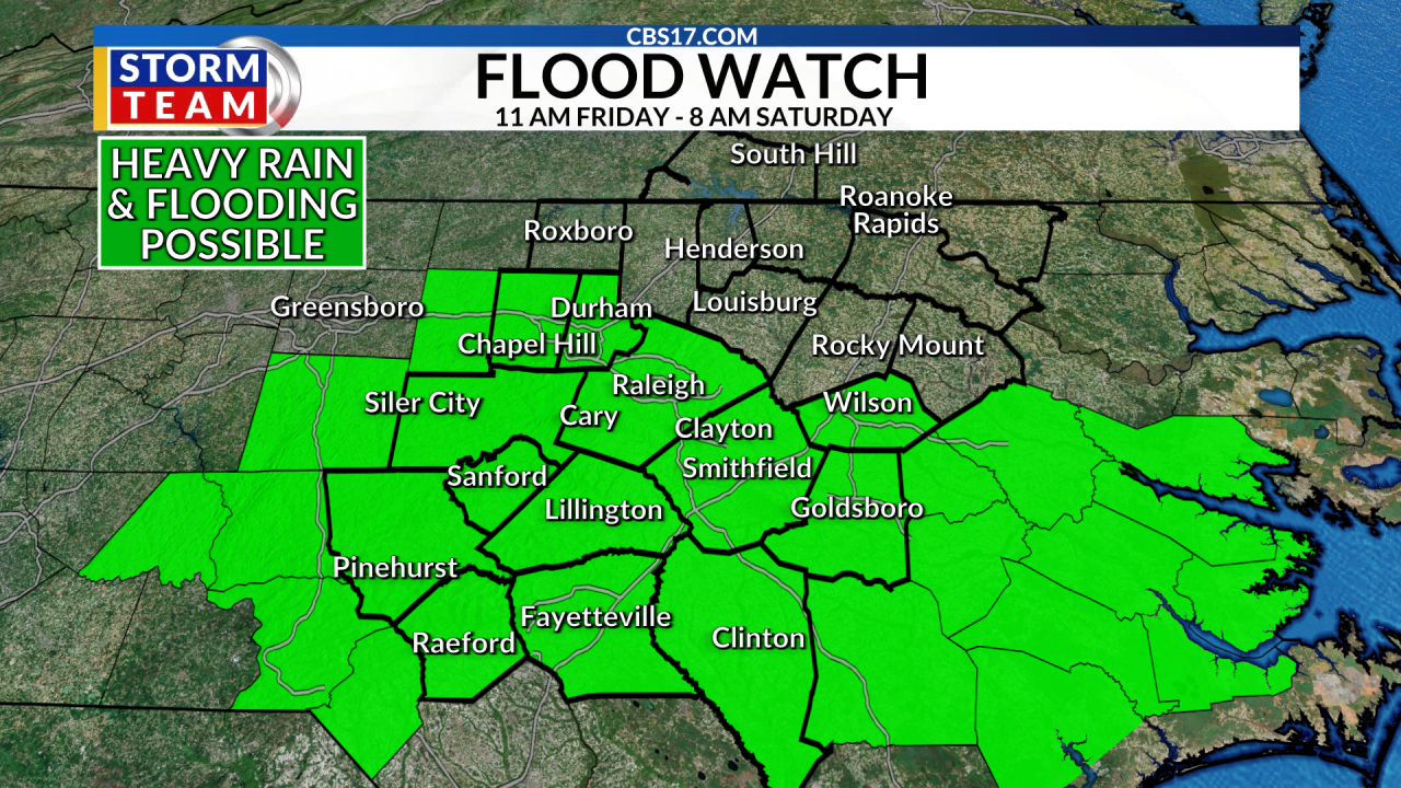
RALEIGH, N.C. (WNCN) — A slow-moving boundary will help create the chance for storms late Friday afternoon into Friday evening that have the potential for damaging wind gusts and heavy, flooding rain.
Read more Antonelli remains the driver to beat as F1 returns at the Dutch Grand Prix
A Flood Watch is in effect for a good portion of central North Carolina as storms could produce more than two inches per hour, creating flash flooding concerns as well as raise creek and river levels.
Additionally, a level 2 slight risk for severe weather is in place south of Raleigh, with a marginal, level 1 risk for areas north of the Triangle. This severe risk is for the potential of damaging wind gusts as storms move through the area.
The most-likely timeframe for flooding rain and strong storms will be between 5 p.m. and 11 p.m. Friday night, but storms are possible by the afternoon and we should all stay weather aware for any changing conditions.
The Flood Watch expires Saturday at 8 a.m. but isolated showers and storms are still possible during the first part of the day Saturday.
The rain chances should come to an end later in the day with gradual clearing skies as the cold front finally moves through. This will make for a lovely and mainly sunny Sunday with temperatures climbing back into the upper 80s.
Next week will start mainly dry, great news for all the kids headed back to school on Monday! Monday morning will start a little more comfortable in the 60s before highs climb into the upper 80s during the afternoon. The rest of the week will have highs back in the mid to upper-80s with a few spotty storms.
For more information about which areas are affected by the flood watch, view the real-time list below.
Read more Prepare for laughter: Rod Man live at Goodnights Comedy Club in Raleigh
⚠️ Current Weather Alerts
FORECAST
FRIDAY will be mostly cloudy with heavy rain and stronger, gusty storms later in the day. The high will be 88. Winds will be out of the northeast, then southeast at 5 to 10 miles per hour.
OVERNIGHT will be mostly cloudy with rain and storms ending. The low will be 71. Winds will be south at 5 miles per hour.
SATURDAY will be mostly cloudy, with scattered showers and storms. The high will be 85. Winds will be out of the south at 5 miles per hour.
SUNDAY will be mostly sunny. The high will be 88. Winds will be out of the northwest at 5 to 10 miles per hour.
MORE FROM CBS 17
CUMBERLAND COUNTY NEWS
Alert Day: Flooding rain expected Friday in central NC
Renovated Fayetteville campus opens as Pauline Jones High School
Sanford fundraiser to honor slain Spring Lake teen

Follow the CBS 17 Storm Team on socials for the latest weather updates:
Chief Meteorologist Wes Hohenstein: Facebook | X | Instagram
Morning Meteorologist Rachel Duensing: Facebook | X | Instagram
Meteorologist Ross Whitley: Facebook | X | Instagram
Meteorologist Matthew Huddleston: Facebook | X | Instagram
This forecast was prepared by the CBS 17 Storm Team and is based on the latest information available and years of weather forecasting experience in North Carolina. It was not produced by a computer like many forecasts you find on the web, social media and smart phone apps.