RALEIGH, N.C. (WNCN) — The stretch of 90-degree heat is coming to an end after today, as a cold front approaches central North Carolina this evening.
Read more This hard-line Iranian general is a major player in talks with US over war
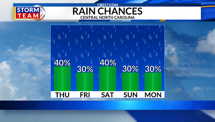
The front arrives late enough in the day that temperatures should still climb into the low 90s before scattered showers and thunderstorms develop late this afternoon and evening. Rain chances will linger into Friday as the cold front slows down and stalls near the area, becoming a stationary boundary. Exactly where that front sets up will play a major role in both temperatures and storm coverage through the weekend.
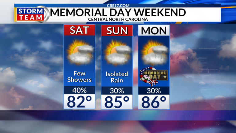
Areas north of the boundary will be noticeably cooler, while communities south of it remain warmer and more humid. Friday could feature one of the sharper temperature contrasts, with the boundary potentially stretching across central NC, leaving the Triangle on the cooler side while the Sandhills stay in the warmer air.
Scattered showers and thunderstorms are expected to develop along the front each afternoon through the weekend. While rain won’t be constant, periods of showers and storms will remain possible each day, especially during the afternoon and evening hours.
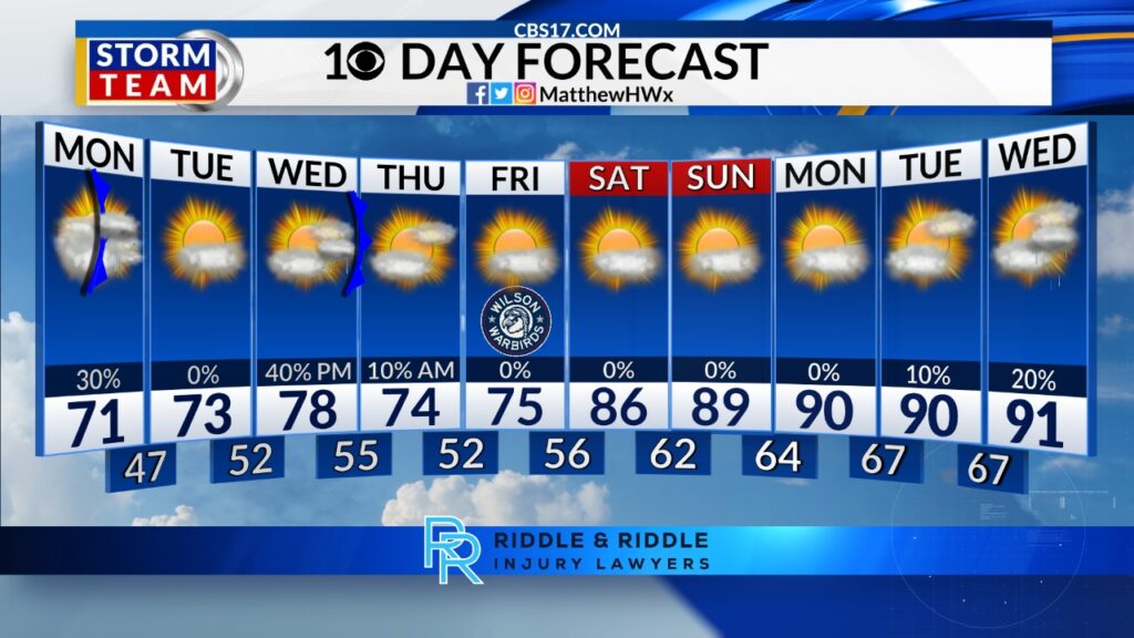
The boundary should gradually weaken and fade by Monday, but the unsettled pattern is expected to continue. Moisture streaming northward around high pressure offshore will keep at least daily chances for pop-up showers and thunderstorms in the forecast through much of next week.
The exact coverage of rain each day will depend on leftover storm boundaries from previous days and the position of the upper-level ridge. Even so, the overall pattern favors continued opportunities for rain, something many across drought-stricken central North Carolina won’t mind seeing.
Read more Golden Knights roll to early lead, hold off Avs 4-2 to open Western Conference Final


FORECAST
THURSDAY will be mostly cloudy with rain and a few storms late in the day. The high will be 90. Winds will be 5 miles per hour out of the east.
OVERNIGHT will be mostly cloudy with showers and storms possible. The low will be 62. Winds will be 5 miles per hour out of the northeast.
FRIDAY will be mostly cloudy with off-and-on showers. The high will be 78. Winds will be 5 miles per hour out of the northeast.
Follow the CBS 17 Storm Team on socials for the latest weather updates:
Chief Meteorologist Wes Hohenstein: Facebook | X | Instagram
Morning Meteorologist Rachel Duensing: Facebook | X | Instagram
Meteorologist Ross Whitley: Facebook | X | Instagram
Meteorologist Matthew Huddleston: Facebook | X | Instagram
This forecast was prepared by the CBS 17 Storm Team and is based on the latest information available and years of weather forecasting experience in North Carolina. It was not produced by a computer like many forecasts you find on the web, social media and smart phone apps.
Read more From hockey exile to playoff spark: Carter Hart’s new chapter with the Golden Knights