 By admin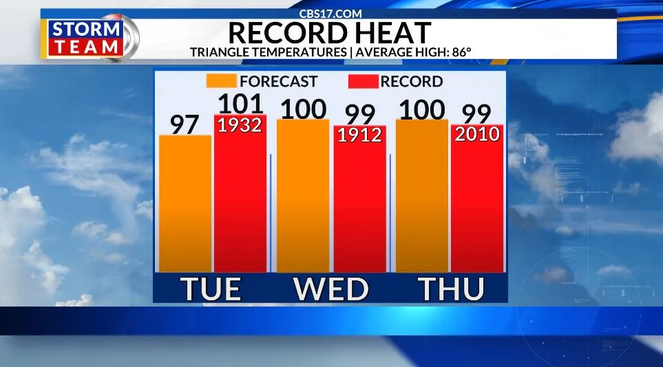
A strong ridge of high pressure will build over the Southeast this week, allowing temperatures to climb rapidly.
Read more United Arab Emirates says it has intercepted an Iranian drone over its territorial waters
Highs will reach the mid to upper 90s by Tuesday before potentially approaching 100 degrees Wednesday and Thursday.
With humidity remaining elevated, heat index values could become dangerously high, and several daily temperature records may be challenged. The upcoming heat will add to what has already been an exceptionally hot year across the region.
Rain will be hard to come by during the hottest part of the week. Most shower and thunderstorm activity should remain closer to the coast, leaving Raleigh and much of central North Carolina hot and mostly dry.
A frontal boundary will approach the area Friday, bringing increasing moisture and a better chance for showers and thunderstorms Friday into Saturday. Rainfall is not expected to be widespread, but any storms that develop could produce locally heavy rain and provide some temporary relief from the heat.
A wind shift to the north and northeast behind the boundary should also help bring noticeably cooler air into the region for the weekend.
Invest 97L in the northern Gulf of Mexico has the better potential for development and is expected to produce heavy rainfall along parts of the Gulf Coast. The remnants of Tropical Storm Dolly are also being monitored for possible redevelopment, although the chances remain lower.
Neither system currently poses a significant threat to the Carolinas, but both will be closely watched as the Atlantic hurricane season enters its peak.
Read more Venus Williams bows out of her 26th US Open with a 1st-round loss to Sofia Kenin
For central North Carolina, however, the immediate concern remains the dangerous heat through Thursday, followed by increasing rain chances and a potential cooldown heading into the weekend.
FORECAST
MONDAY will be mostly sunny and hot. The high will be 95. Winds will be light out of the south.
OVERNIGHT will be partly to mostly cloudy. The low will be 74. Winds will become calm.
TUESDAY will be mostly sunny and hot. The high will be 97. Winds will be light out of the south.

Follow the CBS 17 Storm Team on socials for the latest weather updates:
Chief Meteorologist Wes Hohenstein: Facebook | X | Instagram
Morning Meteorologist Rachel Duensing: Facebook | X | Instagram
Meteorologist Ross Whitley: Facebook | X | Instagram
Meteorologist Matthew Huddleston: Facebook | X | Instagram
This forecast was prepared by the CBS 17 Storm Team and is based on the latest information available and years of weather forecasting experience in North Carolina. It was not produced by a computer like many forecasts you find on the web, social media and smart phone apps.
Read more Leaders of China, Russia and India are among heads of state meeting to counter US influence