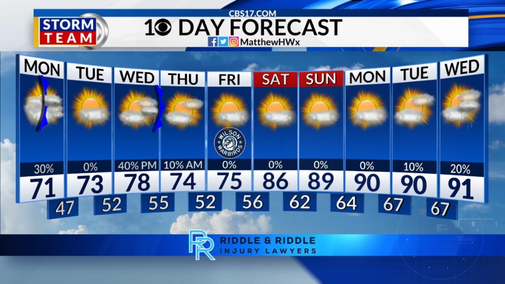
A stationary boundary lifts northward, bringing increasing clouds and a more humid feel on Monday. While a few showers are possible through the day, the best chance for rain will be across the Sandhills and southern counties during the afternoon and evening as a cold front approaches from the north.
Read more Rescuers search for alternative route to reach 2 missing in a flooded Laos cave
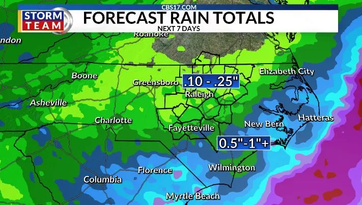
For most of the Triangle and areas farther north, rainfall amounts will be light, generally less than a quarter inch. Communities closer to the South Carolina border could see more meaningful rainfall, with localized totals approaching one-half inch to one inch where showers are more persistent.
Behind Monday’s front, a much drier air mass moves into the region. Dew points will drop noticeably on Tuesday through Thursday, bringing another stretch of comfortable weather with lower humidity and highs mainly in the upper 70s to lower 80s.

The break from summer-like conditions won’t last long. By late week, high pressure will shift offshore and allow warmer, more humid air to surge back into the Carolinas. Temperatures are expected to climb into the upper 80s by Friday and could return to the lower and middle 90s next weekend.
The developing pattern looks very similar to the one that produced the recent stretch of 90-degree days across central North Carolina in May. As a ridge of high pressure strengthens over the eastern United States, both heat and humidity will increase, bringing a much more summer-like feel heading into the second week of June.

FORECAST
MONDAY will be partly cloudy with scattered showers and storms, mainly during the afternoon. The high will be 83. Winds will be 5 miles per hour out of the southwest.
Read more Jerome Powell uses JFK award speech to warn against political pressure on Fed, courts and schools
OVERNIGHT will be partly cloudy. The low will be 61. Winds will be 5 miles per hour out of the northeast.
TUESDAY will be mostly cloudy. The high will be 78. Winds will be 5 to 10 miles per hour out of the northeast.
Follow the CBS 17 Storm Team on socials for the latest weather updates:
Chief Meteorologist Wes Hohenstein: Facebook | X | Instagram
Morning Meteorologist Rachel Duensing: Facebook | X | Instagram
Meteorologist Ross Whitley: Facebook | X | Instagram
Meteorologist Matthew Huddleston: Facebook | X | Instagram
This forecast was prepared by the CBS 17 Storm Team and is based on the latest information available and years of weather forecasting experience in North Carolina. It was not produced by a computer like many forecasts you find on the web, social media and smart phone apps.
Read more Returning to the fold? Some young Spaniards embrace Catholicism and can’t wait for Pope Leo’s visit