Central North Carolina will deal with a mix of summer heat, tropical moisture and an approaching cold front over the next several days. Before the rain arrives, heat remains the headline.
Read more Ukraine hits Moscow oil refinery, disrupting commercial flights in major drone attack
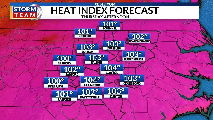
Temperatures climbed into the mid-90s on Wednesday afternoon. Thursday will stay hot and mostly dry for much of the day, with highs again pushing the mid-90s to upper 90s.
By late afternoon and evening, isolated showers and thunderstorms could begin to develop, especially across the Triangle and points north.
The better chance for widespread rain arrives Friday as the cold front moves through and taps into that tropical moisture. The leftovers of Tropical Storm Arthur will bring us the best chance of rain across the area.
A quarter to an inch of rain is possible; any rain is beneficial, as drought conditions continue across parts of the state.
Read more Brunson and Hart throw out first pitches at Yankee Stadium as Knicks celebrate NBA title
Behind the front, drier air moves in just in time for the weekend. Saturday looks comfortable and dry, while Father’s Day on Sunday stays rain-free but warmer, with highs climbing back into the mid-90s.


FORECAST
THURSDAY will be partly cloudy with isolated storms late. The high will be 98 with a heat index of 105. Winds will be 15 to 20 miles per hour out of the southwest.
OVERNIGHT will be mostly cloudy with a shower or storm around. The low will be 74. Winds will be 10 to 20 miles per hour out of the southwest.
FRIDAY will be mostly cloudy with rain and storms. The high will be 91. Winds will be 10 miles per hour out of the west.
Read more New Yorkers are set to fete the Knicks with a ticker-tape parade