
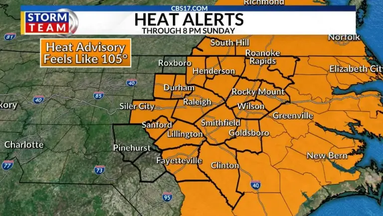
Sunday will bring another day of dangerous heat across central North Carolina, with afternoon highs around 102 degrees. When combined with the humidity, heat index values will once again climb into the 105 to 110 degree range, making prolonged time outdoors hazardous.
Read more Female American rower completes record-breaking solo journey from California to Hawaii
The same strong dome of high pressure responsible for the holiday weekend heat remains firmly in place, keeping skies mostly sunny and rain chances very limited.
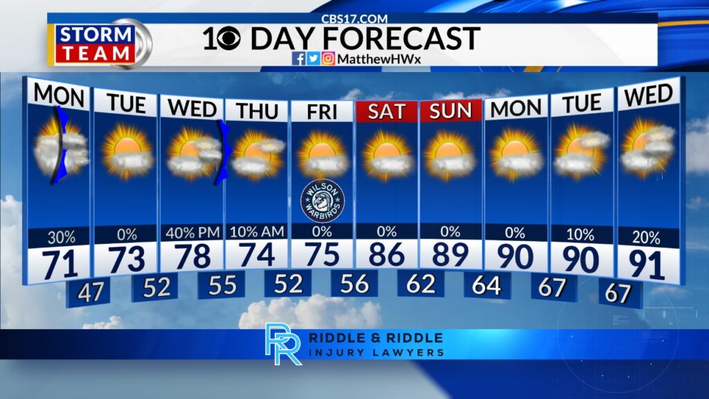
The pattern finally begins to shift on Monday as the ridge weakens and deeper Gulf and Atlantic moisture returns. That will allow scattered showers and thunderstorms to develop during the afternoon and evening.

At the same time, not everyone will see rain; any storm that forms will be capable of producing torrential downpours, frequent lightning, and gusty winds. The added cloud cover and rain will also help trim temperatures back a few degrees compared to the weekend.
By the middle of next week, the historic heat wave will be behind us, but summer isn’t going anywhere. High temperatures settle back into the lower to middle 90s, much closer to normal for early July, while humidity remains high.
Expect the return of a more typical summertime pattern with a daily chance for isolated to scattered afternoon and evening thunderstorms, offering occasional relief from the heat but not ending it altogether.
Read more Heavy rains leave 5 dead in China’s north while Tropical Storm Maysak hits the south and Vietnam
FORECAST
SUNDAY will be partly cloudy and very hot. A stray shower or storm in the afternoon is possible. The high will be 102 with a heat index of 107. Winds will be southwest at 5 miles per hour.
OVERNIGHT will be mostly clear. The low will be 76. Winds will be southwest at 5 miles per hour.
MONDAY will be partly cloudy and very hot. Scattered showers or storms in the afternoon are possible. The high will be 100 with a heat index of 105. Winds will be southwest at 5 to 10 miles per hour.
Follow the CBS 17 Storm Team on socials for the latest weather updates:
Chief Meteorologist Wes Hohenstein: Facebook | X | Instagram
Morning Meteorologist Rachel Duensing: Facebook | X | Instagram
Meteorologist Ross Whitley: Facebook | X | Instagram
Meteorologist Matthew Huddleston: Facebook | X | Instagram
This forecast was prepared by the CBS 17 Storm Team and is based on the latest information available and years of weather forecasting experience in North Carolina. It was not produced by a computer like many forecasts you find on the web, social media and smart phone apps.
Read more July brings the heat to central NC