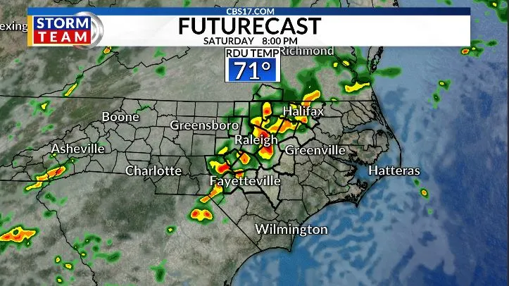
Saturday brings one of the better chances for rain, especially during the afternoon and evening hours when showers and thunderstorms are expected to become more widespread from west to east. Anyone heading out to evening events or tailgates should be prepared for wet weather.
Read more Behavior of teen in mosque shooting led police to seize family guns a year before attack
Unlike a typical cold front sweeping through, this pattern features several weak disturbances moving nearby, making the timing of rain more difficult to pinpoint.


The result will be an unsettled stretch with scattered showers and storms developing at times rather than one continuous washout.
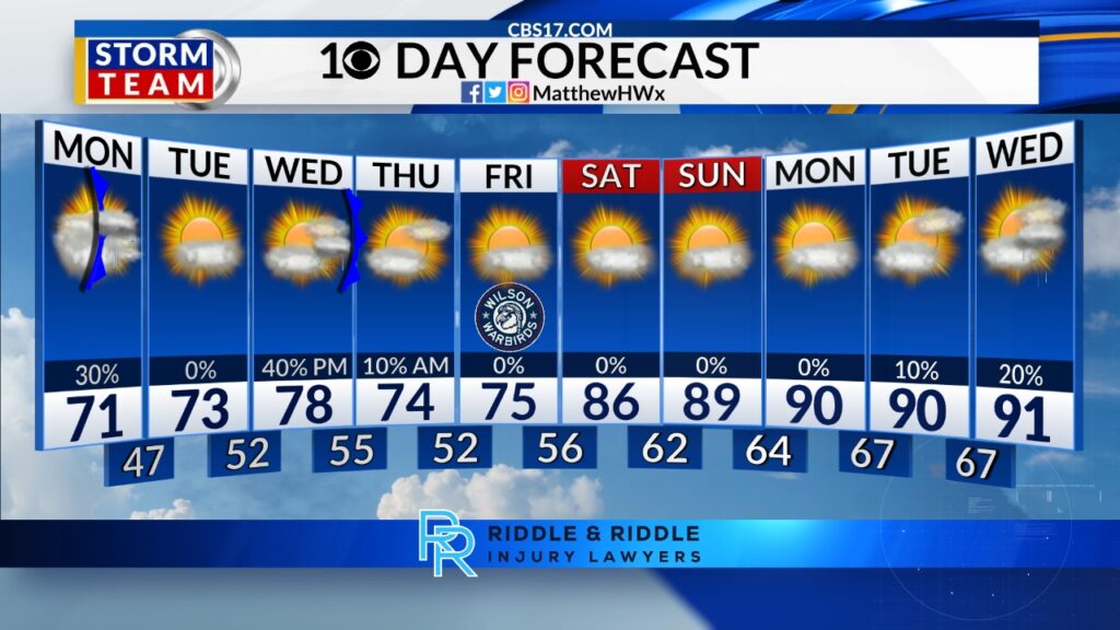
Rain chances remain elevated through Sunday and Memorial Day, although there will still be dry periods mixed in. The weekend will not be a total washout, but some locations could see brief heavy downpours and localized higher rainfall totals if thunderstorms repeatedly move over the same areas.


Over the next seven days, many locations could pick up an additional 2 to 3 inches of rain, with isolated higher amounts possible. Some communities already saw over an inch of rain from recent storms, and the active pattern should continue helping chip away at ongoing drought conditions.


Temperatures will stay cooler than average through much of the upcoming week, with highs mainly in the 70s as clouds and scattered rain chances linger into Tuesday and Wednesday before conditions gradually begin to improve later next week.
Read more Woman hurt after Eureka Avenue shooting, Cumberland County Sheriff’s Office says
FORECAST
SATURDAY will be mostly cloudy with rain and storms, mainly in the afternoon and evening. The high will be 77. Winds will be 5 miles per hour out of the south.
OVERNIGHT will be mostly cloudy with periods of showers and storms possible. The low will be 66. Winds will be 5 to 10 miles per hour out of the south.
SUNDAY will be mostly cloudy with a few spotty storms. The high will be 83. Winds will be 5 miles per hour out of the south.
Follow the CBS 17 Storm Team on socials for the latest weather updates:
Chief Meteorologist Wes Hohenstein: Facebook | X | Instagram
Morning Meteorologist Rachel Duensing: Facebook | X | Instagram
Meteorologist Ross Whitley: Facebook | X | Instagram
Meteorologist Matthew Huddleston: Facebook | X | Instagram
This forecast was prepared by the CBS 17 Storm Team and is based on the latest information available and years of weather forecasting experience in North Carolina. It was not produced by a computer like many forecasts you find on the web, social media and smart phone apps.
Read more Man shot on Bud Lipscomb Road in Wake County, sheriff’s office says