Overnight will feature passing clouds with lows in the upper 50s and lower 60s ahead of a spectacular Mother’s Day Sunday.
Read more Central NC Mother’s Day outdoor plans look great, showers back for Monday
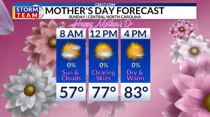
The second half of the weekend will feature clouds to start, with afternoon sunshine and warmer highs in the lower to middle 80s.
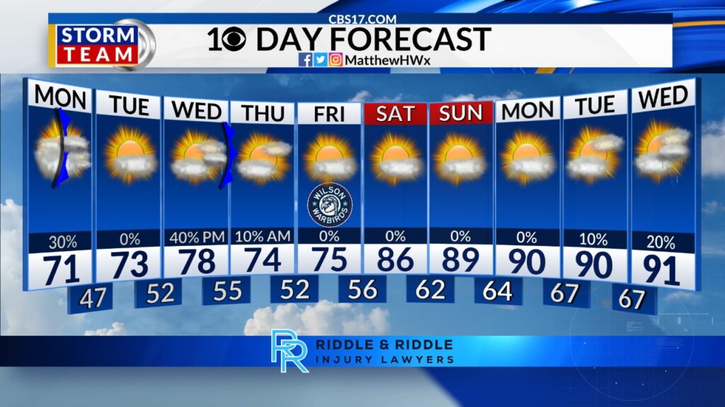
A cold front on Monday will bring cooler temperatures in the lower 70s and another good chance for rain. As much as 0.25”+ is expected. It’ll be dry on Tuesday before yet another round of scattered showers on Wednesday into early Thursday.
Then the pattern we became so familiar with in April returns towards the end of next week into the start of the following week. High pressure will ridge in, turning the pattern dry and warming highs back near 90 degrees once again.

FORECAST
OVERNIGHT will be partly cloudy. The low will be 57. Winds will be light out of the southwest.
Read more Rain and cooler temperatures return Monday in central NC after dry, warm Sunday
SUNDAY will be partly cloudy early with afternoon sunshine for Mother’s Day. The high will be 83. Winds will be 5 miles per hour out of the southwest.
MONDAY will be mostly cloudy with scattered showers. The high will be 72. Winds will be 5 to 10 miles per hour out of the north.
Follow the CBS 17 Storm Team on socials for the latest weather updates:
Chief Meteorologist Wes Hohenstein: Facebook | X | Instagram
Morning Meteorologist Rachel Duensing: Facebook | X | Instagram
Meteorologist Ross Whitley: Facebook | X | Instagram
Meteorologist Matthew Huddleston: Facebook | X | Instagram
This forecast was prepared by the CBS 17 Storm Team and is based on the latest information available and years of weather forecasting experience in North Carolina. It was not produced by a computer like many forecasts you find on the web, social media and smart phone apps.
Read more Cold front with central NC showers on Monday ahead of pattern change