A combination of a summer high-pressure ridge and a lee-side trough helped fuel the extreme temperatures while limiting widespread rainfall.
Read more Another round of central NC record highs likely Sunday, with threat for severe weather
Another Heat Advisory is in effect for the Triangle through the Sandhills until 8 p.m. due to heat index values as high as 102+ degrees.

It gets even worse on Sunday, so a Heat Advisory is likely again.
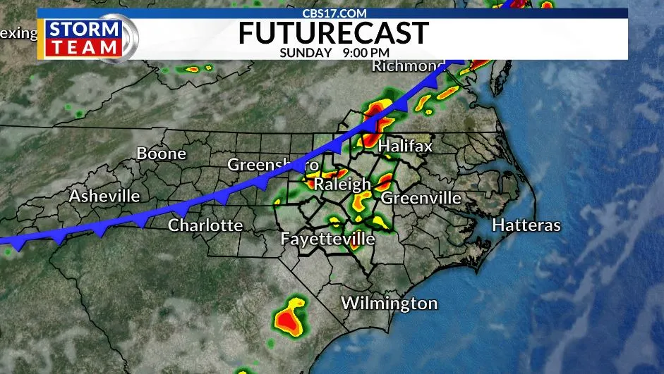
The good news is that some relief is on the way. Isolated storm chances return Saturday, but the better opportunity for more widespread rain arrives Sunday as a cold front pushes through the Carolinas.
Any storms that develop this weekend could produce gusty winds. During the summer months, collapsing thunderstorms can mix stronger winds from higher in the atmosphere down to the surface, leading to localized wind gusts of 50 to 60 miles per hour.
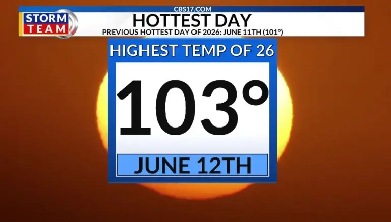
Friday’s 103-degree reading marked one of the hottest days in recent memory. It was the second 100-degree day of the month and the 14th day this year that Raleigh has tied or broken a daily temperature record.
While central North Carolina typically experiences around 50 days of 90-degree heat each year, this week’s stretch has been among the most intense of the season so far.
Read more Real Madrid parts ways with soccer coach Álvaro Arbeloa, setting up Mourinho’s return
Behind Sunday’s front, temperatures will finally ease. Highs will fall to around 89 degrees on Monday before dropping into the mid-80s by Tuesday, offering a welcome break from the extreme heat. Rain chances will also increase early next week, raising hopes for some much-needed moisture after continued dry conditions.
The cooldown won’t last forever, however. Forecast trends suggest temperatures will gradually climb back into the lower 90s later next week. Still, compared to the upper 90s and triple-digit heat we’ve endured, that will feel like a much more manageable taste of summer.


FORECAST
SATURDAY will be partly cloudy with scattered showers and storms. The high will be 96 with a heat index of 99. Winds will be 5 miles per hour out of the northeast.
OVERNIGHT will be mostly cloudy and muggy with a shower or storm around. The low will be 73. Winds will be calm.
SUNDAY will be mostly clear with another chance for scattered storms. The high will be 99 with a heat index of 104.Winds will be 5 to 10 miles per hour out of the southwest.
Read more A ‘rowdy’ Knicks watch party ends with 21 in custody and 5 officers injured