 By admin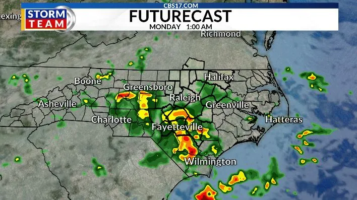
Several days of isolated, hit-or-miss storms, deeper tropical moisture, and a weakening area of high pressure will allow showers and thunderstorms to become more widespread Sunday afternoon and evening. While it won’t be a washout, many communities have a much better chance of seeing beneficial rainfall.
Read more From Darkness to Hope: Tisha Temple’s Journey to Recovery
On Monday, periods of showers and thunderstorms are expected throughout the day, with the greatest coverage during the afternoon and evening. Some locations could pick up over an inch of rain, with locally higher totals where storms repeatedly track over the same areas. This will help chip away at the recent dry conditions, but it may also lead to areas of ponding on roads and localized flooding in poor drainage locations.

Temperatures will also trend downward thanks to the increased clouds and rainfall. Highs will be cooler into the upper 80s on Sunday and Monday, providing a break from the recent stretch of intense summer heat. As always, any thunderstorm will be capable of producing frequent lightning, torrential downpours, and gusty winds.
The heat returns in the middle of the week as highs range back into the mid 90s. Rain chances return as upper-level troughing will keep showers and storms part of the forecast later in the week and next weekend.

FORECAST
SUNDAY will be mostly cloudy and slightly cooler with scattered showers and storms. The high will be 88. Winds will be northeast at 5 to 10 miles per hour.
Read more NC secures up to $165 million in Cash App settlement over alleged safety issues: AG Office
OVERNIGHT will be mostly cloudy with lingering showers and storms. The low will be 69. Winds will be northwest at 5 miles per hour.
MONDAY will be mostly cloudy to start with showers and storms, then partly cloudy. The high will be 84. Winds will be northeast at 5 to 10 miles per hour.

Follow the CBS 17 Storm Team on socials for the latest weather updates:
Chief Meteorologist Wes Hohenstein: Facebook | X | Instagram
Morning Meteorologist Rachel Duensing: Facebook | X | Instagram
Meteorologist Ross Whitley: Facebook | X | Instagram
Meteorologist Matthew Huddleston: Facebook | X | Instagram
This forecast was prepared by the CBS 17 Storm Team and is based on the latest information available and years of weather forecasting experience in North Carolina. It was not produced by a computer like many forecasts you find on the web, social media and smart phone apps.
Read more Record heat slams central NC